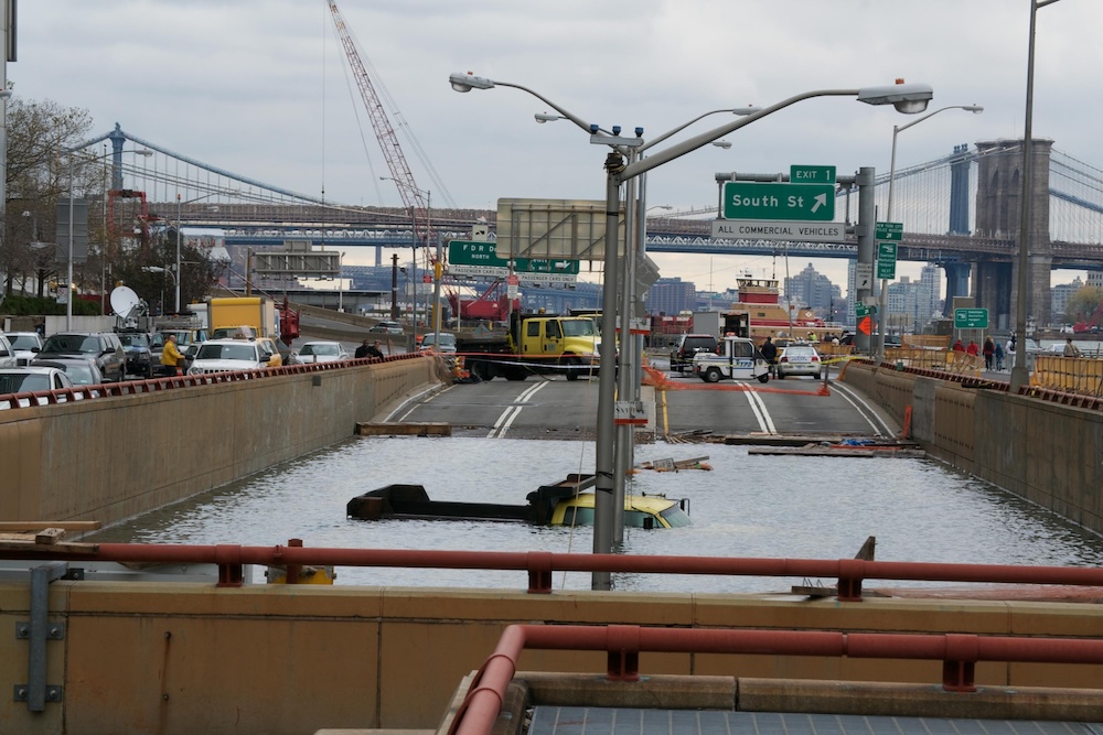

On 11 October 2012, a disorganised tropical wave crossed the Atlantic Ocean from western Africa. Upon reaching the warm waters of the Caribbean, favourable conditions allowed it to form into a tropical depression, escalating into a major hurricane by 24 October. While initially heading northeast and appearing to curve out to sea, an unusual combination of atmospheric conditions forced the storm to make a sharp westward turn. Suddenly, Hurricane Sandy was heading directly for the East Coast of the United States.
The impact was catastrophic. A massive volume of water smashed into New York Harbor, carrying waves exceeding nine metres. The storm surge overtopped bulkheads, completely flooding Lower Manhattan. Tunnels were inundated, and hospitals were forced into emergency evacuations. At the East 13th Street Substation, equipment failures caused massive power cuts, leaving more than 220,000 residents in the dark. In the Breezy Point neighbourhood, electrical fires destroyed 130 homes. Across the broader region, 650,000 homes were damaged or destroyed, and nearly 200 lives were lost.
Sandy caused around $19 billion of damage in New York City and up to $70 billion across the region. Governor Andrew Cuomo put it bluntly: “Anyone who says, ‘this is just one in a million’, anyone who says ‘this is a fluke and won’t happen again’ is denying reality. This is the new reality. This is the new normal. It is something we have to plan on. It will happen again. And we have to be prepared.”
No city can pay a recovery bill of tens of billions over and over. Resilience means building for the next storm: understanding the actual risks and the needs of the communities affected, while leaving room to adapt to a future nobody can predict.
Rising expectations and changing realities
Public patience with infrastructure failure is running out. Gregg Herrin, Vice President for Water at infrastructure engineering software company Bentley Systems, has watched expectations rise. His interest in civil engineering started in childhood, when bolts failed on the town reservoir, which sat on a hill next to his house. The burst flooded the reservoir road and his family’s driveway. He started asking his father, a civil engineer, why anyone would put water on top of a hill.
Today, Herrin sees a public that expects its systems to work all the time. “I think we’re at a point where the public tolerance for lagging is no longer here,” Herrin explains. “Nobody is willing to accept the idea that their street floods sometimes. Nobody is okay with the idea that once in a while their water supply is poisoned. You know, nobody’s okay with the idea that sometimes bridges fall down.”
Herrin thinks rising expectations will push the industry towards better solutions. But engineers are dealing with ageing infrastructure while designing for a changing environment.
“One of the challenges that we have with infrastructure, kind of by its nature is we build things that have a lifespan of 30 years, 50 years, 100 years, and who knows what the world is going to look like in 10 years,” Herrin says. “And so part of the challenge there is how do we build things in a way where unknown future scenarios feed into the decision making that we have to make today.”
The workforce is changing too. Digital natives who buy concert tickets on their phones are joining an industry that still uses paper charts. Fewer engineers will have to deliver more projects, and Herrin argues that only technology can close that gap.
The era of digital twins and systems thinking
Digital twins, 3D visualisation and connected data let engineers model complex variables and test trade-offs before construction starts. A digital twin is somewhere to make mistakes cheaply.
“To make a mistake digitally is really inexpensive, right? To find out that your design doesn’t work really costs you nothing. To make a mistake in the real world, really, really expensive,” Herrin notes.
Digital twins also pull together information that used to sit apart. GIS data and asset registries can be combined with engineering data and live sensor readings, giving a picture of how an asset is working and what surrounds it.
They can also be linked into a system of systems. If a city closes its floodgates, a connected twin can show what that means for evacuation routes, emergency vehicle access and the electricity grid.
City departments have tended to work separately, and open data is starting to change that. “Every one of those historically has run in isolation,” Herrin points out regarding city departments. “But increasingly, there’s that recognition that combining information from these different previously disparate silos of departmentalism can actually result in better insights for everybody.”
Herrin sees AI as a force multiplier, not a replacement for engineers. Model Context Protocols (MCPs) connect AI assistants directly to validated engineering software such as STAAD.Pro and MicroStation, so the AI works from engineering models rather than general web data. In infrastructure design, there is no room for hallucinations.
The Eastside Coastal Resiliency project
One project using these tools is the Eastside Coastal Resiliency project in Lower Manhattan, which will protect the Lower East Side and East Village from storm surge.
Roni Deitz, Global Director for Climate Adaptation at Arcadis, came to the work through two hurricanes. Ike made landfall three weeks into her first year at Rice University in 2008. Four years later, she watched Sandy hit New Jersey, where she grew up.
“Hurricane Sandy yet again really shaped my career in that I was really drawn to the coastal side of things, and having grown up in New Jersey, watching Hurricane Sandy impact New Jersey, impact New York City, felt like this call to action,” Deitz recalls.
The line of protection runs alongside the FDR Drive, dense residential neighbourhoods, public housing, utility lines, and transportation routes.
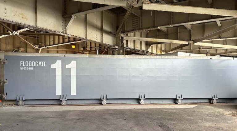
Continuous protection needs many kinds of structure. Above ground there are flood walls, raised berms and deployable floodgates where roads, bikeways and footpaths cross the line. Below ground there is parallel conveyance (improved drainage), two large interceptor gates that can cut off the main sewer, and foundations that stop seepage under the walls.
“The challenge isn’t simply how do we build a flood wall; it’s really how do we incorporate flood protection into a very much living city without disrupting everything that the city depends on,” Deitz explains.
Under the streets, utilities have built up over generations. “I always kind of joke about construction in New York City, and think of it as trying to figure out how to do open heart surgery with the patients still right there awake,” Deitz notes. To manage this subsurface complexity, her team relies on 3D environments and digital twin technology to model how water will move through drainage systems and how seepage will travel beneath flood walls.
From thirty hours to thirty minutes
The clearest example of what the software changed is the structural analysis of the floodgates.
Done manually, with calculations, design and quality control, portions of the structural analysis for each gate took about 30 hours. The team used Bentley’s open APIs to automate it.
“Our team developed an automated analytical process that reduced the work to roughly 30 minutes,” Deitz says.
Saving 29 and a half hours per gate matters, but for Deitz the bigger change is to the engineering process. “When an analysis takes 30 hours, every iteration is expensive in terms of time… It’s another lengthy analytical cycle,” Deitz explains. “But when you reduce that as dramatically as our team did, engineers can really iterate much more freely. You can test more conditions.” With the manual calculation gone, engineers can test more configurations and respond faster when other disciplines change the design.
City building and the path forward
Deitz describes Eastside Coastal Resiliency as a city-building project that also provides flood protection. It has to improve life on sunny days, not only perform when a storm arrives.
Her lessons from the project: design for several outcomes from day one, because multiple benefits make a large investment easier to justify; treat community impact as seriously as engineering performance, including interim amenities while parks are closed; and build in room for future upgrades as climate projections change.
For Deitz, the hard part now is delivery.
“I think that we need to, as an industry, figure out how to move towards implementation faster. And the hardest part is moving from understanding risk into a funded project,” Deitz urges. “I think we’ve become very good at diagnosing climate risk. I think we can produce better maps, better models, better assessments than ever before. But at the same time, a risk assessment doesn’t protect anyone.”
Getting from plan to construction means funding, permitting and community engagement. Not every city has New York’s budget, but Herrin argues the method scales: understand the problem, the options, what each costs and what it would achieve.
On Eastside, engineers, agencies, owners and residents worked from one shared view of the problem and its trade-offs. For Herrin, the biggest lesson is a human one: “Infrastructure projects aimed around resiliency don’t have to compete with other community outcomes.”