
For offshore wind developers, knowing what lies beneath the waves is a fundamental part of designing and building a project. Before turbines, foundations and cables can be installed, survey teams need to build up a detailed picture of the seabed and what lies beneath it.
For Roger Birchall, technical authority for geophysics at SSE Renewables, the technology used to gather that information is secondary to the quality of the result.
“I’m a geophysicist, and I don’t care how the data is collected. What I want is good, clear data that delivers the answers that I expect.”
That is becoming a demanding requirement as offshore wind projects get larger.
One of SSE Renewables’ major projects is Berwick Bank, off the east coast of Scotland. The company has already carried out surveys for the export cables and, following the award of AR7 in January, is moving towards the final pre-construction surveys needed to determine the routes of the intra-array cables and the final positioning of the export cable.
SSE Renewables is also developing North Falls, an extension to the existing Gabbard wind farm off Suffolk, while looking further ahead to floating wind projects including Ossian. The company is also involved in projects in Japan, Ireland and at Holland’s IJmuiden Ver Alpha site.
Building a picture of the seabed
The scale of these projects makes the survey task difficult to appreciate. Berwick Bank is expected to have more than 200 turbines across its phases, with hundreds of kilometres of intra-array cables and an export cable route of around 80km to landfall near Dunbar.
The water depths across the site vary considerably.
“It’s – around the shallowest point, I would say – it’s around 38 metres and in its deepest points that we wouldn’t develop, but we may lay cables through, is down to about sixty odd meters,” Birchall says.
Before survey vessels head offshore, the work begins with a desktop study. Teams examine geological information, existing charts and protected or consented areas to establish potential routes for cables connecting the wind farm to the onshore grid.
The offshore surveys then build up a much more detailed picture.
Hydrographic surveys measure the depth of the seabed and use techniques such as side-scan sonar to identify features on its surface.
“We like to look at the seabed features to see if there’s anything, you know, we’re looking for wrecks, steep slopes, boulders, all of those kinds of things… debris. We use side scan sonar for that,” Birchall says.
Geophysicists also need to know what is below the seabed. Sub-bottom profilers are used to establish the thickness of sediments above bedrock and identify geological features that could affect cable installation.
At Berwick Bank, for example, surveys identified ancient igneous dykes crossing a potential cable route. These remnants of prehistoric volcanic activity meant that additional surveys were needed to establish how the route could be moved around them.
Magnetometers provide another layer of information, helping to identify buried metal objects such as old cables, debris and unexploded ordnance.
It is a process that takes time. Surveying for Berwick Bank began with Fugro in 2019, while the detailed pre-construction surveys need to be completed roughly a year before construction.
“We try and get those surveys started in spring with a view to getting the data by the end of spring, early summer,” Birchall says. “The data’s analysed through summer, early autumn, ready for the next spring to begin because we have to clear the seabed of boulders, of debris, maybe even remove the odd cable, maybe do some dredging.”
Why take people off the vessel?
Traditionally, collecting all this information meant putting a sizeable crew aboard a survey vessel. That brings its own set of constraints.
Simon McIlroy, survey systems architect at Fugro, says many of those constraints have historically come from the needs of the people working on the vessel.
“Historically our vessels have been designed around personnel and people being on board the vessel. And so, a large amount of the design considerations that limit the constraints of the platform are around the motion of the vessel around its ability to carry people, to be able to have a galley and carry a large amount of energy generation equipment, and fuel for supporting people on board the vessel.”
Removing the crew changes the equation.
“When we move to an uncrewed solution, we can design a vessel which is tailored specifically as a data collection platform,” McIlroy says. “And so, the focus is on the sensors and the quality of the geodata, primarily over some of the other considerations which have historically driven vessel design.”
There is a safety benefit too. Birchall points out that a vessel operating around the clock with 10, 15 or 20 people working 12-hour shifts creates a large amount of safety exposure.
Fuel use is another consideration. Conventional survey vessels can burn as much as five tonnes of marine gas oil a day.
Uncrewed surface vessels, or USVs, offer a way to reduce both the human and environmental footprint of survey work.
But early USVs had a significant limitation: they could not necessarily carry all the equipment required to conduct a full geophysical survey in one go.
From two passes to one
Fugro’s development of USVs has taken place in stages. The company launched Blue Shadow in 2019 for hydrographic surveys, followed by the 12m Blue Essence in 2022, which uses an electronic remotely operated vehicle, or eROV, called Volta for inspection and monitoring. In 2026, it introduced the 18m Blue Eclipse, equipped with the larger Amp eROV.
For complex site surveys, however, size and payload remain important.
Birchall says earlier USVs could require two separate passes to collect the necessary information: one configured for bathymetry and sub-bottom profiling, and another towing equipment such as side-scan sonar and magnetometers.
That adds time and cost to the survey and, importantly, leaves the project exposed to changing weather conditions.
“One of the barriers always to USVs, is it comes down to size and your ability to run multiple sensors on a vessel,” says Marco Gilisen, global director for marine geophysics at Fugro.
Fugro’s answer is the Blue Prism, a 17m USV developed specifically for geophysical site surveys. The company acquired USV builder SEA-KIT in 2023.
“The Blue Prism is of course our first fully dedicated site screening geophysics USV in the business,” Gilisen says.
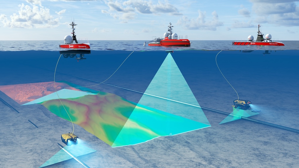
The vessel is designed to carry a combination of hull-mounted and towed equipment, allowing several different types of data to be collected during the same survey operation.
“With the Blue Prism, we will achieve that in a single pass,” McIlroy says. “So, we will be able to collect all the geodetic parameters that we need to, and the geodata that we need to, in a single pass, making the platform much more efficient.”
There is an obvious operational advantage to collecting the data together. Bathymetry, side-scan sonar and magnetometry measurements are gathered at the same time and in the same location, rather than being collected during separate passes that subsequently have to be aligned.
The vessel also uses considerably less fuel than a conventional crewed survey ship, with Fugro reporting a reduction of around 95%.
USVs can also remain offshore for several days and operate beyond direct line of sight. In the UK, changes to maritime regulation, including the Maritime and Coastguard Agency’s Workboat Code Edition 3, have helped make this type of operation possible.
A vessel that can be sent where it is needed
Another advantage of an uncrewed vessel is that it can be deployed relatively quickly when something unexpected happens.
During foundation installation at Dogger Bank, Storm Babette passed through the site. A USV was available to carry out a post-storm survey of the seabed.
“So, we had a USV available and it was retasked, shall we say, and that was the point it could go in quickly,” Birchall recalls. “It can go very close to the wind turbines themselves because they’re highly manoeuvrable.”
That flexibility can matter when construction vessels are already on standby. Birchall puts the cost of a heavy construction vessel at between £100,000 and £200,000 a day, compared with around £10,000 to £20,000 a day for a USV.
Fugro is now building five Blue Prism vessels at the same time. Using the same sensor configuration across the fleet should allow the vessels to be deployed to different projects, or several to be used on a single project when survey programmes need to be completed quickly.
The people operating them, meanwhile, can be hundreds or thousands of miles away.
Fugro’s Remote Operations Centres monitor the vessels and their survey equipment remotely, receiving data from the vessel and providing operators with video, radar and information about the vessel’s position and motion.
For Gilisen, one of the biggest challenges is recreating the awareness that a surveyor would have on board.
“One of the biggest things with a USV, in particular a geophysics USV, is that sense of spatial awareness,” he says. “You know, it’s one thing to be sitting on the back deck of a vessel as a surveyor or an engineer and monitoring your sensors out and visually seeing what’s happening and what the environmental conditions are. But remove that person and put them in a remote operation centre sitting halfway around the world – or maybe close by in the nearest remote operations centre – you need a different set of technology, a different set of cameras, a different set of visualization, more different monitoring of the motions of the vessel and having that data available at the control centre, the command and control end of the ROC.”
Fugro has also been able to draw on experience from its work supporting space exploration from its Australian Remote Operations Centre. The same concerns around redundancy, data integrity and risk management apply when the person making decisions is physically separated from the vehicle.
The challenge of floating wind
The case for larger and more capable survey vessels becomes even stronger as offshore wind moves into deeper water.
SSE Renewables’ Ossian floating wind project is one example. The project is much further offshore than a typical fixed-bottom wind farm, creating long export cable routes.
“So Ossian, one cable route extends from up there in Scotland and came ashore somewhere in Lincolnshire. So, the export cable route that we did, the scouting survey we did for that was 420 kilometres long,” Birchall says.
Floating wind also changes what needs to be surveyed around each turbine.
In conventional oil and gas developments, Birchall says survey areas around structures could be relatively small. A jack-up rig might have three points where it contacted the seabed, while a semi-submersible could have eight anchor points.
A floating wind farm can involve far more.
“We’ve done the calculations and if one of our patterns for Ossian, one of our WTG patterns is to be followed, we would have 1,440 touch points,” Birchall says.
The survey area under consideration measures roughly 20km by 40km, with more than 1,400 individual points associated with the anchoring systems and dynamic inter-array cables.
Those cables introduce another consideration. Unlike fixed cables buried beneath the seabed, dynamic cables associated with floating turbines can move across or close to the seabed as conditions change.
That means survey teams need to understand not only the physical characteristics of the seabed, but also its environmental sensitivity. Protected reef formations, Sabellaria worm colonies, ocean quahog habitats and herring spawning gravels can all influence how infrastructure is designed and installed.
The result is a survey problem that is getting larger in almost every direction: more turbines, longer cables, deeper water, more complex seabed interactions and more environmental constraints.
For offshore wind developers, the appeal of USVs is therefore not simply that they can operate without people on board. The more significant change may be their ability to put more sensors on a single platform, collect different types of data at the same time and send that information back to shore while the vessel remains at sea.
For projects covering hundreds of square kilometres and requiring thousands of individual seabed investigations, that could make the difference between surveying an increasingly complicated ocean floor in several stages and building the picture in a single operation.